16.08.2025 21:55
The current state of the "sunken city," which was submerged under the sea during the Marmara Earthquake on August 17, 1999, in the Gölcük district of Kocaeli, was captured in images 26 years later.
```html
The current status of the "sunken city" that was submerged during the 17 August 1999 Marmara Earthquake in Gölcük district of Kocaeli was recorded 26 years later.
The 7.4 magnitude Marmara Earthquake, which had its epicenter in Gölcük, caused great destruction and loss of life 26 years ago. During the earthquake, a part of the coastline at Çınarlık Square in Değirmendere neighborhood was submerged, and buildings, vehicles, and piers were left underwater.
DIVE CONDUCTED
After the passing years, a dive was conducted by underwater photographer and documentary producer Tahsin Ceylan, Hakan Arslan, Vice President of the Turkish Underwater Sports Federation (TSSF), Murat Kulakaç, the founding president of the Değirmendere Underwater Community and a First Class Diver, and Yoshinori Moriwaki, a Japanese civil engineer, architect, and earthquake expert.
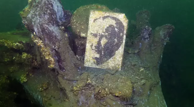
In the dive supported by Kocaeli Metropolitan Municipality and the Değirmendere Underwater Community, the areas that were submerged that night were brought back to light. The images clearly showed a tea garden, plane trees, concrete remnants, chairs, a gazebo, and walls with tiles.
Experts reported that the structures remaining on the seabed were largely preserved, but the metal parts had rusted over time. The images are important in terms of reminding the reality of earthquakes and raising awareness of disasters.
ONCE A SQUARE, NOW 30 METERS UNDERWATER
Tahsin Ceylan told AA reporter that the location of the boat during the shoots used to be the center of Çınarlık Square, and now most of the square is submerged 30 meters underwater.
Ceylan noted that when buildings were destroyed and new ones were built after the earthquake, it was thought that the traces of the earthquake had been erased, stating, "If there is a place where the traces of the earthquake have not been erased, it is that sunken city in Değirmendere. We made those recordings to remind of the earthquake memory on August 17. Right now, the larger plane trees in the square are all underwater, and that area has now become an artificial reef. Lobsters, swallow fish, and many creatures now use it as a nest."
Ceylan reminded that Turkey is located in an earthquake zone and emphasized the need for the country to be prepared for earthquakes.
“THERE IS NO SIMILAR EXAMPLE IN THE WORLD”
Ceylan stated that they conducted the dive to keep the memory of the earthquake alive, and continued his speech as follows:
"There is no example in the world similar to Çınarlık Square. The only example is actually that Çınarlık Square in Gölcük in our country. Everyone needs to dive there and face the reality of the earthquake. We dived to a depth of 50 meters there. Some of those plane trees and some structures from that period were exactly 50 meters deep. The beach where the people of Gölcük and Değirmendere used to stroll, spend time, and relax in the tea garden, and the plane trees that protected them from the sun are now underwater. They preserve the traces of the earthquake and bring them back to light."
```