25.04.2025 15:44
The tsunami risk has come to the forefront again following the 6.2 magnitude earthquake that occurred in Istanbul. A tsunami risk map covering the coasts of Istanbul and the Marmara Region has been developed by Muğla Sıtkı Koçman University. Associate Professor Dr. Ceyhun Özçelik stated that the map identifies the flood areas that could be affected by potential tsunami waves following an earthquake in the Marmara region.
```html
On April 23, a 6.2 magnitude earthquake occurred in the Marmara Sea off the coast of Silivri, Istanbul, leading to the formation of large waves in the Bosphorus. The 6.2 tremor, reminiscent of the potential Marmara earthquake that experts frequently warn about, has brought the tsunami risk back to the forefront.
TSUNAMI RISK MAP DEVELOPED
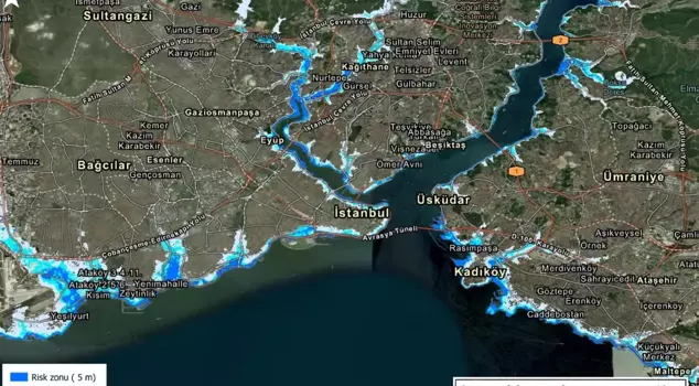
Assoc. Prof. Dr. Ceyhun Özçelik, Director of the Geographic Information Systems and Remote Sensing Center (CBS-UZAL) at Muğla Sıtkı Koçman University (MSKÜ), developed a map showing the flood areas that would be affected by a tsunami along the coasts of Istanbul and Marmara following the 6.2 magnitude earthquake off Silivri. Dr. Özçelik emphasized the vital importance of predicting the effects of a potential tsunami after a Marmara earthquake in advance.
"IT WILL BE MORE PRONOUNCED IN LOW-SLOPE COASTAL AREAS"
Dr. Özçelik stated that accurately predicting the potential effects of an earthquake and tsunami in the Marmara is important for timely informing citizens, saying, "This way, precautions can be taken before the disaster, and post-disaster interventions and planning can be made more effective. The prepared risk zones cover areas that could be affected by 5, 10, and 20-meter sea floods in coastal regions. The maps provide a comprehensive risk assessment that includes many factors such as tsunami wave height, landslides, tides, and terrestrial floods. The effects of the tsunami will be more pronounced, especially in low-slope coastal areas. In contrast, we anticipate that the effects in the inner bays of Marmara, the Golden Horn, and around the Bosphorus will be more limited," he said.
"THIS MODEL ALLOWS FOR MORE ACCURATE PREDICTIONS IN URBAN AREAS"
Dr. Özçelik mentioned that the risk maps were prepared using data from the Advanced Land Observing Satellite (ALOS) developed by the Japan Aerospace Exploration Agency, and continued his remarks as follows:
"This model, unlike classical topographic maps, takes into account the structures on the earth's surface, allowing for more accurate predictions, especially in urban areas. The maps are important not only for institutions but also for our citizens. They will serve as a guide for each individual to take their own precautions."
```