08.02.2025 14:32
The Disaster and Emergency Management Authority has deployed a mobile siren system to İzmir, Aydın, and Muğla for potential tsunamis and emergencies. The system established by AFAD will quickly and effectively alert the local population to possible dangers.
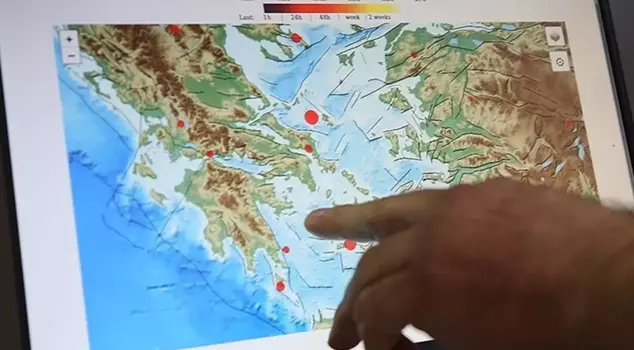
As earthquakes in the Aegean Sea continue to occur one after another, a seismic activity and potential risk assessment meeting was held at AFAD for Santorini Island.
In the written statement made after the meeting, important details were included. The statement said, "In the evaluation meeting chaired by our Deputy Minister of Interior, Mr. Münir Karaloğlu; the potential dangers that a larger earthquake, tsunami, or volcanic eruption that may occur as a result of the seismic activity observed around Santorini Island in the Aegean Sea since January 28, 2025, could pose to our country's coasts, as well as the precautions and preparations taken, were evaluated with AFAD, MTA, General Directorate of Meteorology, Kandilli Observatory, and Earthquake Research Institute, expert scientists, and researchers."
The statement continued with the following details:
"As a result of the activity in the region developing in the form of an earthquake storm, the number of earthquakes greater than 3 reached 761 as of February 7, 2025. The largest recorded earthquake is 5.2 Mw in magnitude. Earthquakes are increasing approximately 25 km northeast of Santorini Island, with depths ranging from 5 km to 25 km. The closest earthquake to our country's coasts is 140 km away. The earthquakes are concentrated in the region of the Kolumbo volcano, which has an underwater crater located 6.5 km northeast of Santorini Island in the Southern Aegean Volcanic Island Arc.
SEISMIC ACTIVITY INTENSITY WAS ALSO EXPERIENCED IN 2011-12
The last known volcanic eruption in the region occurred in 1950. In 1956, an earthquake of 7.5 Mw occurred on the active Yamurgi (Amorgos) fault located northeast of Santorini Island. Although there is a slight possibility that the ongoing seismic activity in the region may lead to potential volcanic activity, a similar intensity of seismic activity was experienced in the same region for 14 months in 2011-2012, but it did not lead to any volcanic activity.
WHAT IS THE DANGER FOR TURKEY?
As a result of a possible eruption, the effects of volcanic ash material, which is fine-grained and carried by the wind, or potential tsunami risks that may occur after an earthquake, could reach our country, just as historical records indicate.
MOBILE SIREN SYSTEM HAS BEEN DEPLOYED
Since the moment seismic activity began to intensify, a committee consisting of AFAD Earthquake Advisory Board, MTA General Directorate, General Directorate of Meteorology, Kandilli Observatory, and Earthquake Research Institute, along with scientists from our country, has been formed to continuously monitor the situation from different perspectives. A mobile siren system has been deployed to the provinces of Izmir, Aydın, and Muğla to warn the local population in case of potential tsunamis and emergencies.
THE SYSTEM IS READY FOR EMERGENCIES
Our existing system is ready to send SMS messages to our citizens in case of potential emergencies through the news gathering and dissemination system. Reinforcement personnel and equipment have been assigned from the Provincial AFAD Directorates of Ankara, Antalya, Bursa, Diyarbakır, Sivas, and Samsun to the command of the Governors of Izmir, Aydın, and Muğla. Integration has been made with the Tsunami Warning System of Kandilli Observatory and Earthquake Research Institute and AFAD Disaster Management and Decision Support System (AYDES), allowing future tsunami warnings to be directly communicated to all AYDES users and citizens in the region.
The General Directorate of Meteorology prepares daily reports to analyze the distribution and movement direction of volcanic gas and ash that may arise in the event of potential volcanic activity. At the same time, AFAD Provincial and Union Directorates in the region have been put on alert, and supporting provinces are on standby.
Starting from February 10, a delegation consisting of AFAD, MTA, General Directorate of Meteorology, Kandilli Observatory, and Earthquake Advisory Board, along with scientists, will hold informational meetings in the provinces (Muğla, Aydın, and Izmir) under the coordination of AFAD.
Scientific information exchange is being conducted with universities and research institutions in Greece.
WARNING TO CITIZENS ABOUT DISINFORMATION
AFAD, MTA, General Directorate of Meteorology, Kandilli Observatory, and Earthquake Research Institute, along with the Earthquake Advisory Board, scientists, and researchers in our country are monitoring seismic activity in coordination with AFAD regarding earthquakes, volcanism, and tsunami risks. Citizens are requested not to trust disinformation content shared on social media and to follow official sources for accurate information.