20.09.2024 14:12
In the Karapınar district of Konya, more than 100 sinkhole formations are increasing due to climate change and uncontrolled groundwater usage. The sinkholes threaten agricultural lands and settlements.
In the Karapınar district of Konya, there are more than 100 sinkholes with varying diameters and depths, and in some areas of the agricultural land, the distance between two sinkholes drops to 5 meters. Sinkholes are formed by the dissolution of limestone underground over time, creating voids and causing the ground to collapse. The increasing number of sinkholes in the Konya Plain, exacerbated by climate change, drought, and uncontrolled use of underground water, is raising concerns.
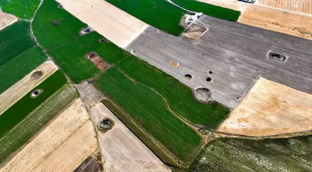
In the fields of Eşeli Plateau, located within the borders of Reşadiye Neighborhood in the northwest of Karapınar, where the formation of sinkholes has rapidly increased in recent years, numerous sinkholes are observed.
In a photo taken from the air, 24 sinkholes are visible in an area where the distance between two sinkholes drops to 5 meters, and there are more than 100 sinkholes with varying diameters and depths.
THE REGION WITH THE HIGHEST DENSITY OF SINKHOLES CAPTURED FROM THE AIR
Prof. Dr. Fetullah Arık, the Director of the Sinkhole Research and Application Center at Konya Technical University, told AA correspondent that the number of sinkholes has increased in areas where many sinkholes have formed. Indicating that the number of sinkholes, which began to be seen in the 2000s in Reşadiye Neighborhood, has increased, Arık stated: "After 2007, several sinkholes have formed almost every year, spreading in this region. The sinkholes are very close to each other. We are in the area with the highest density of sinkholes at this depth. There are agricultural lands in this area. Some of the sinkholes that have occurred here are also within residential areas. Therefore, they pose a danger. The number of sinkholes in the region has been increasing due to the ongoing drought and the use of underground water for agricultural irrigation since the 2000s."
THERE ARE 8 SINKHOLES IN ONE FIELD
Arık pointed out that there are a significant number of sinkholes in areas where agriculture is common, saying: "There are 8 sinkholes in one field, and their formation continues. In satellite images, this area looks like a sieve, resembling a lunar surface, as if it is a region with a high density of craters. The formation of 8 sinkholes in the same field is a serious problem. In the past, sinkholes occurred in higher areas and places where people did not live, and they were seen as interesting karstic shapes for us geoscientists. However, in recent years, the sinkholes that have formed are now very close to residential areas, agricultural, and investment lands. Therefore, they pose a danger."