28.04.2025 12:23
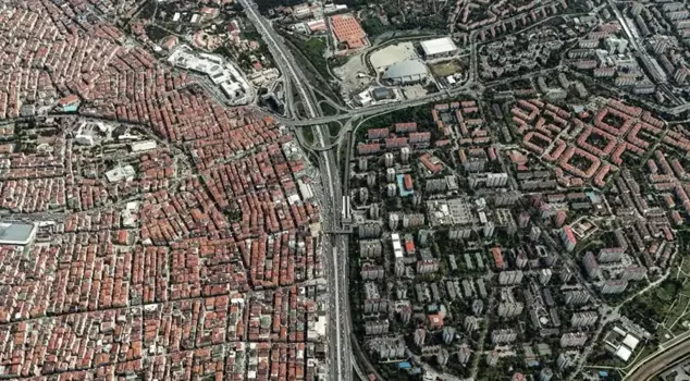
Following the earthquake that occurred in Istanbul, the different urbanization structures in Ataköy and Şirinevler, which are located side by side, have become a topic of discussion once again. The region, which came to the forefront with satellite images, was captured from the air. The images highlight that Ataköy has a more organized structure, while Şirinevler has a denser urban development.
After the 6.2 magnitude earthquake that occurred in Istanbul on April 23, the very different urbanization landscapes of Ataköy and Şirinevler have come back to the agenda. The region, which has been highlighted with satellite photos, was captured from the air. The aerial images of Şirinevler, which is part of the Bahçelievler district, and Ataköy, which is part of the Bakırköy district, draw attention with their two different urbanization landscapes.
THE OPPOSITE SIDES OF E-5
The aerial images show that Ataköy, separated from neighboring areas by the E-5 highway, has a more organized structure, while Şirinevler has a denser construction. Especially after the 6.2 magnitude earthquake that occurred in Istanbul on April 23, comparisons made through satellite photos of these two regions have become a hot topic on social media.