13.09.2024 14:10
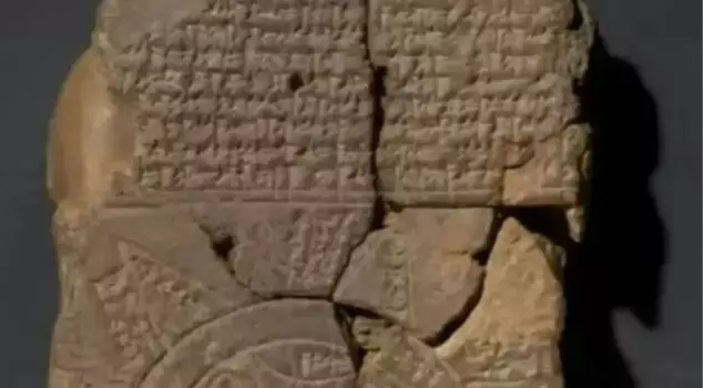
The 3000-year-old 'Imago Mundi' tablet, considered the oldest map in the world, has been deciphered at the British Museum. The map, dating back to the 6th century BC, shows Mesopotamia and the boundaries of the known world. It reflects the Babylonians' worldview, their belief in the god Marduk, and mythological creatures. Additionally, another tablet revealing that the Babylonians considered lunar eclipses as a sign of death has also been recently deciphered.
The 3000-year-old tablet, which has been shrouded in mystery for centuries and is believed to be the oldest map in the world, has finally been deciphered. This map, called "Imago Mundi," dates back to the 6th century BC and provides a bird's-eye view of Mesopotamia, shedding light on the Babylonians' beliefs about the known world at that time.
Acquired by the British Museum in 1882, the cuneiform tablet could only be deciphered with the discovery of a missing piece. The tablet contains a series of paragraphs describing the creation of the world and the things believed to exist beyond the Earth at that time.
The map shows ancient Mesopotamia, which encompasses modern-day Iraq, and is surrounded by a double ring called the "Bitter River." This ring marks the boundaries of the known world at that time.
Dr. Irving Finkel, a cuneiform expert from the British Museum, explains, "In this circular diagram, you can see the entire known world where people lived, developed, and died. But there is more to this map."
Researchers confirm that the circle around Mesopotamia indicates that the Babylonians saw this region as the center of the world. The map also shows the ancient Mesopotamia being intersected by the Euphrates River.
The tablet also confirms the Babylonians' beliefs in their creation god Marduk and mythological creatures such as the scorpion-man and the lion-headed bird called Anzu. The ancient Babylonians had a story called Utnapishtim, which was a version of Noah's Ark.
Another Babylonian mystery that was recently deciphered was the code found on a 4000-year-old tablet. These texts reveal that the Babylonians saw lunar eclipses as ominous signs of death and destruction.