05.02.2025 12:21
Prof. Dr. Hasan Sözbilir from İzmir Dokuz Eylul University stated that the AFAD earthquake application allows people to be informed about earthquakes and that it is possible to escape from life-threatening waves 20-30 minutes before a tsunami reaches the shores. Sözbilir also emphasized that "it is important for the AFAD application to be installed on all smartphones."
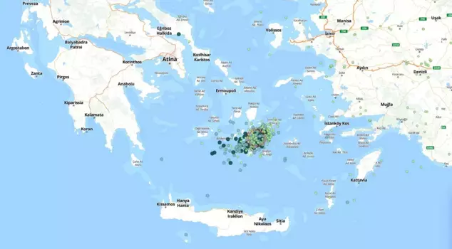
As of January 28, a significant increase in seismic activity in the Aegean Sea has resulted in hundreds of earthquakes in the region. The earthquakes, concentrated about 25 kilometers northeast of Greece's Santorini Island, with depths ranging from 5 to 25 kilometers, have caused concern. The possibility of a tsunami threat for the Aegean coasts has also come to the fore in relation to the earthquake swarm.
'MEGA EARTHQUAKES UP TO 8.5 IN THE PAST'
Prof. Dr. Hasan Sözbilir, Director of the Earthquake Research and Application Center (DAUM) at İzmir Dokuz Eylul University (DEÜ) and Faculty of Engineering, Department of Geological Engineering, provided an assessment regarding the earthquake swarm that has intensified around Santorini Island since January 28. Prof. Dr. Sözbilir stated, "On average, there are about 100 earthquakes daily, with magnitudes ranging from 1 to 5. The Santorini Island forms a bow-shaped geometry starting from Greece's capital Athens, encompassing the islands of Milos, Santorini, and Nysiros, extending to the Kula volcanoes on the Turkish mainland. This bow-shaped geological environment is referred to as the Southern Aegean Volcanic Island Arc. The characteristic of this volcanic island arc is that it is currently active. A significant portion of the volcanic islands within the island arc has erupted several times in the last 10,000 years, causing tsunamis, earthquakes, and loss of life and property. Will this volcanic activity cease? The answer lies in the bigger picture. To the south of the island arc is Crete. To the south of Crete, there is a massive fault that forms the geological boundary between Africa and the Aegean-Anatolian plates. This fault progresses southeast from Albania, presenting a bow shape as it passes through southern Greece and southern Crete, then curves northeast to merge with the Pliny-Strabo transform fault south of Rhodes Island. Mega earthquakes of up to 8.5 in magnitude have occurred along this fault in the past," he said.
'CAN TRIGGER EARTHQUAKES UP TO 7.5'
Prof. Dr. Sözbilir pointed out that geophysical studies conducted in the region over the last 20 years have revealed that magma activity in the underwater volcano located northeast of Santorini and Amorgos has risen to a depth of 2.8 kilometers. "The formation of fractures and cracks in this area, as well as the involvement of hydrothermal-geothermal fluids along active faults, is evident. There is a possibility that these ongoing tectono-magmatic activities under the sea may reach the surface through fractures and cracks after a certain period and transform into volcanic activity. Of course, this activity could also trigger earthquakes of up to 7.5, as it has in the past," he stated.
'THERE ARE RECORDS OF TSUNAMIS OCCURRING ON TURKEY'S SOUTHWEST COASTS'
Prof. Dr. Sözbilir noted that there have been both earthquakes and volcanic activities in the past related to this issue, stating, "There have been volcanic eruptions on the islands of Santorini, Milos, and Nysiros in the years 1600 BC, the 1800s AD, and in 1950, and due to these volcanic activities, tsunamis occurred on the Greek islands, resulting in loss of life and property. In particular, there are records of tsunamis occurring on Turkey's southwest coasts -Kuşadası-Bodrum-Datça-. The ashes from the volcanic activity that occurred on Santorini Island around 1600 BC have been detected within the young units in our coastal regions such as Datça, Bodrum, and Söke. This suggests that in the event of such an explosion, volcanic ashes could reach the Aegean coasts. In such a case, citizens can be informed about volcanic precautions available on the websites of institutions like AFAD," he expressed.
CALL TO DOWNLOAD THE APPLICATION ON PHONES
Prof. Dr. Sözbilir stated that it is known that a 7.5 magnitude earthquake occurred north of Santorini in 1956, followed by a 7 magnitude aftershock 13 minutes later. "After these earthquakes, tsunamis of up to 1-2 meters are reported along our Aegean coasts. I do not think a serious problem will arise if such an event occurs. Because this earthquake has been modeled. When an earthquake exceeding 7 occurs around Santorini, the seismometers connected to AFAD and other relevant seismology stations detect the earthquake within a few seconds. The AFAD system automatically analyzes the data and shares it with the whole world. If there is a tsunami threat, messages are sent to all smartphones containing the AFAD application. The tsunami may reach our shores approximately 20-30 minutes after this message. If we move 4-5 kilometers inland from the coastline during this time, there will be no loss of life. Perhaps some buildings on the coast will be flooded by seawater, but it will recede afterward. Therefore, it is crucial to continuously monitor the websites of official authorities like AFAD and the Governor's Office and to download the AFAD application on all smartphones," he concluded.